 he road west to the mound called Hısarlık takes sweeping bends past fields of corn and purple-flowered cotton. It has two or three gradual hills, but the chief obstacles are the odd tour bus or tractor-load of tomatoes. It is, by and large, a smooth and untroubled approach to a world-famous archeological site. Not so the scholastic approach—a road of zigzag switchbacks through fields of criticism and intrigue, littered with sharp shards of controversy: The obstacles here are implications in journal articles, tendentious newspaper interviews and downright insults.
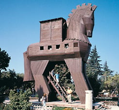
We arrive on a glorious August morning just as the orange ball of the sun lights the treetops and the replica of the larger-than-life wooden horse. The air
is quiet except for the distant putt-putt
of an irrigation pump. It is believed by many that this is the place the blind poet Homer called Troy, where he set his tale of the abduction of the beautiful Helen by Paris, the son of King Priam of Troy; of the arrival of a force of 1000 Greek ships under the command of King Agamemnon; and of the consequences that followed 3200 years ago.
 |
 |
Is this where it happened? At only 200 by 150 meters (650' x 490'), the mound seems small to first-time tourists, many of whom hope to see the massive walled city depicted in the recent movie. There are walls—dozens of them—but to the untrained eye they are a confusing jumble of cut stones at all angles and levels. After all, there are over 4000 years of human history here, stacked in nine levels and 47 sublevels, and dating from Bronze Age 3000 BC through the classical Greek and Roman period to the Byzantine era—in all, 15 different fortifications. And every new arrival tore down existing structures for building stone. Throw in the odd earthquake, the occasional fire and a number of sieges, and the site becomes an excavator’s nightmare.
The westerly breeze keeps the mosquitoes at bay but
does nothing to clear the haze to the north, where plodding freighters and tankers enter the Dardanelles Strait six kilometers (3 1/2 mi) away bound for Istanbul and Black Sea ports. Westerly? This is indeed unusual, for it was the prevailing northeasterly winds that were the reason for this site’s existence during the years of the purported Trojan War. Techniques for sailing into the wind then lay a millennium in the future, so hundreds of ships waited for weeks at a time in nearby Beşik Bay for a westerly, or unloaded their cargo for a costly overland trip into the Anatolian heartland and beyond. Either way, Troy was in the right place to exact a price. At least, so believes Manfred Korfmann.
Korfmann, an intense 62-year-old archeologist from Tübingen University, has directed the Troia Project here since its inception 16 years ago. Very much in charge, he greets
us after giving his morning orders to workers in German-accented Turkish. He views Troy as a crossroads of Bronze Age commerce. “Troy provided access from the Aegean through to the Black Sea, gave access to the Danube, the rivers of the Pontic steppe and the Caucasus, and to important stone and metal sources,” he says, adjusting his ascot tie as we climb into his pickup for a tour of the excavations.
 |
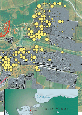 |
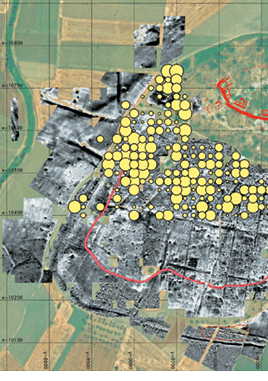
| On one of the Troia Project’s maps of the excavations, the size of the yellow circles indicates relative concentrations of Bronze Age surface finds. The known defensive walls of the city are in red. |
 |
rade and commerce hasn’t always concerned researchers here—it was more a quest for the truth behind the myth. An adventurer named Robert Wood kicked it off when he walked the bandit-ridden Troad in 1742 and claimed it matched Homer’s description. His controversial book ignited debate. Skeptics said Troy never existed, but others were smitten: In 1810 Lord Byron rode at anchor for days in Beşik Bay, fantasizing, before hiking the famous battle plain. But, everyone wondered, where was the city of Troy?
From Hısarlık, we can see several other mounds. Debate raged as to which of them might be the real Troy; by the
late 1800’s, Pinarbaşı, a few kilometers to the south, was
a favored candidate. But there was a dissenter—one Frank Calvert, arguably the discoverer of the real Troy. The Calvert family had lived in the area for generations and Frank had played on and hiked over these mounds as long as he could remember. After a team of German archeologists dug Pinarbaşı and came up empty-handed, Calvert bought the northern half of Hısarlık from a local farmer and dug a few trial trenches of his own. The hints of potsherds and walls were tantalizing, but mounting a large-scale dig required cash.
One day 136 years ago, a wealthy middle-aged German entrepreneur, who claimed to have been obsessed with
Troy since he was a boy, first set foot on Hısarlık and saw Calvert’s trenches. Probably the most controversial excavator of all time, Heinrich Schliemann was to be called “the father of Anatolian archeology” and would soon change
the face of Hısarlık more than anyone since the Romans. His fortunes had been made in various fields of business—but he had often been accused of cheating and lying his way to success. He was bright. He wrote voluminously
—letters, diaries, books, in English, German, Turkish, Russian and other languages—but many of the “facts” he wrote have proved wrong.
When he met Frank Calvert, each man thought this would be the match-up of the century. Calvert saw cash
in the man with the finely tailored suit. Schliemann saw Calvert as the man who’d lead him to world glory as the discoverer of fabled Troy. But the pushy Schliemann was overanxious: Without official permission, he began digging on the southern half of Hısarlık. “Knowing in advance that the two Turkish owners would refuse to give me permission, I did not ask them,” he later wrote. And when he finally obtained his fırman, or excavation permit, from the Turkish government, he blandly ignored stipulations that one-half of any finds go to the state and that existing structures not be demolished.
Demolish he did. We’re looking to the north through a cut 40 meters wide (130') that runs straight through the mound. Dubbed the “Schliemann trench,” it’s 17 meters (55') deep and still used in undergraduate archeology courses as a prime example
of how not to excavate. In 1871, in his haste to get to what he thought would be the levels representing Homeric Troy, Schliemann hauled out hundreds of tons of earth, ordering his 160 laborers to raze everything in their way. Little did he know that he had torn right through the Homeric levels he sought—the Late Bronze Age, around 1200 BC—as well as through a thousand-
year earlier period before hitting bedrock.
Calvert was appalled—so much that he refused Schliemann permission to dig on his half of the mound. Schliemann called Calvert a “foul fiend,” but pressed on. Then he claimed that on May 31, 1873, he had made one of the most famous and controversial finds in the history of archeology—the “Treasure of Priam.” It included fabulous gold: diadems, a headband, 60 earrings and 8750 small ornaments found stashed inside
a silver vase. To keep it a secret, he ordered his laborers to take an extended early break and, as he wrote in his diary, himself “cut out the Treasure with a large knife…. It would have been impossible for me to have removed the Treasure without the help of my dear wife,” he added, “who stood by me ready to pack the things which I cut out in her shawl and to carry them away.” (It was later shown that his wife had in fact been away from the site that day.) And Schliemann spirited the treasure to Athens, where he jubilantly announced to the world he had found the palace of King Priam.
 The treasure didn’t stay in Athens long. Schliemann rushed his find to Berlin, where it stayed until the final
days of World War ii. Russian troops moved in and hastily loaded it onto a train, and the treasure remained hidden from the world until 1994. Now most of the stunning artifacts are on display at Moscow’s Pushkin Museum of Fine Arts, and ownership is claimed by Turkey, Germany and a few of Frank Calvert’s heirs.
The treasure didn’t stay in Athens long. Schliemann rushed his find to Berlin, where it stayed until the final
days of World War ii. Russian troops moved in and hastily loaded it onto a train, and the treasure remained hidden from the world until 1994. Now most of the stunning artifacts are on display at Moscow’s Pushkin Museum of Fine Arts, and ownership is claimed by Turkey, Germany and a few of Frank Calvert’s heirs.
 orfmann has been investigating this mound longer than anyone, so I ask his opinion of Schliemann. He pauses, one foot on the pickup’s running board. “I wouldn’t want to be his personal friend,” he says. “But people are unfair—he obviously wasn’t a treasure hunter: He was already very rich.” In sifting through Schliemann’s old trenches and spoil heaps, he says, “we haven’t found any mistakes. We have found nothing that Schliemann missed.”
David Traill, professor of classics at the University of California, shares Korfmann’s distaste for Schliemann, but
is less positive about his accuracy. “With an individual like Schliemann, we always need to be on our guard,” he told
me in an earlier interview. “I believe he was a psychopath…. There was a slightly inhuman aspect to him.” Traill says he has come to know Schliemann as well as anyone can today, spending a decade poring over his papers and diaries and writing an exhaustive analysis in 1995 (Schliemann of Troy: Treasure and Deceit, John Murray Publishers). “To psychopaths there’s no difference between lying and telling the truth,” he says. “Most people now accept the fact that Schliemann’s archeological reports are tainted with untruths.”
 cademics need truths—and they need them as soon as possible after they’re excavated. Ironically, timely publication of results was one of Schliemann’s strong points. By 1875, he had published his three years of controversial digging; summing them up, he wrote, “It is not to be expected that science would gain anything more from further excavations.”
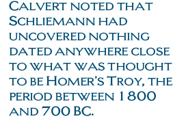
That, however, was far from the truth. Using analogies from Near Eastern archeology, Calvert had meanwhile been doing his homework. He noted that Schliemann had uncovered nothing dated anywhere close to what was thought
to be Homer’s Troy, the period between 1800 and 700 BC. Schliemann’s famous treasure clearly had nothing to do
with the legend.
Stung, Schliemann hired a bright young researcher named Wilhelm Dörpfeld. Soon both were accused of misleading the public, so they mounted another excavation campaign in 1889. The following year they discovered Mycenean pottery at Troy VI levels—confirming that the site indeed contained Late Bronze Age remains, but forcing Schliemann to admit that his golden trove was not Priam’s Treasure but instead dated from a thousand years earlier. He planned another excavation, but died in 1890. Dörpfeld continued digging and found the remains of a great conflagration and destruction at the top of the Troy VI level. He was convinced that Level VI was Homeric Troy.
But stratigraphic sequencing was still in its infancy at the end of the 19th century, so precise dating was impossible. Excavations were abandoned until 1932, when a professor from the University of Cincinnati named Carl Blegen turned his attention to Troy. Fresh from a series of excavations on the Greek mainland, he came armed with the latest techniques and an intimate knowledge of Mycenean stratigraphy. Creating a landmark in professional archeology at the time, his team systematically reevaluated all levels in the years 1932 to 1938; curiosity was of course greatest about Troy VI.
Blegen was convinced the destruction at Troy VI was not the result of war, but of a huge earthquake. So he excitedly focused on Troy VIIA as the level of the famed siege. (He found that Schliemann had erroneously separated the two levels, which actually represented the same culture. Nonetheless, Schliemann’s numbering has stuck.) After the earthquake, Blegen said, the citizens rather shoddily rebuilt the place, constructing small, gloomy houses and extensive storage. To him, the hovels represented a siege mentality: laying in stores and hunkering down, waiting for an attack. And, he figured, the attack did come: He found charred wood and rubble, human skeletons trapped indoors and covered in debris, skulls crushed by stones—and
one bronze arrowhead. He even matched the dates with his studies on the Mycenean mainland, showing that the invading city-states would have been at their richest at the time and best able to mount the attack. “It is settlement VIIA, then, that must be recognized as the actual Troy,” he wrote. “It can no longer be doubted.”
 ut doubted it certainly was. Critics immediately blasted Blegen’s “evidence,” pointing out that storage jars do not necessarily imply a siege mentality, and that one arrowhead does not make a war. They also challenged his pottery dating. After Blegen’s last dig, Troy lay unexcavated for another 50 years, and the controversy smoldered.
Part of the controversy over both Schliemann’s and Blegen’s ideas was that, until the 1930’s, there was scant knowledge of adjacent Anatolian civilizations; there were no written references to Troy from the Late Bronze Age. It was then that Swiss scholar Emil Forrer deciphered newly discovered writings from the Hittite Empire to the east, finding two place-names—Wilusa and Taruisa—that sounded convincingly like the Hittite way of writing “Wilios” (the Greek name for the site was “Ilion”) and “Troia” (Troy). He also found a treaty, from the early 13th century BC, between the Hittite king Muwatalli and a king of “Wilusa” named Alaksandu. The king’s name, Forrer added, recalls the name of the Trojan prince Alexander—called Paris in Homer’s Iliad.
Critics pooh-poohed, conceding that a place named Wilusa may have existed, but where was it on the map? For decades the question remained unanswered. Then, in the mid-1980’s, new pieces of text were discovered: a letter from Hittite king Manapa-Tarhunda that narrowed Troy’s location to the Troad. It also became clear from other Hittite texts that Wilusa was attacked repeatedly by “Ahhiyawans,” thought to have been Mycenean Greeks, in the 13th century BC.
 “That’s when a Trojan War should fit in,” says Korfmann, bouncing over dusty potholes,
“if such a war actually took place. All this ended about 1190 or
1180 BC,” he says with a sweep
of his arm, “with a catastrophe, evidenced by fires and casualties.” He says the 13th century was
evidently the most critical time
for Troy and a time of intense pressures: The archeologists found vulnerable gates walled up; they found pithoi, large storage vessels, everywhere; and, tellingly, they found piles of sling stones that the Trojans had left behind. “Only a victorious invading army would behave
in this way,” Korfmann says. “Had Troy, or Wilusa, been successfully defended, piles of this sort would have been removed shortly after the catastrophe.” This kind of implication ensures that the Late Bronze Age still gets the attention here. Korfmann steps off the truck and we clamber up a sequence of dusty wooden planks to where a Polish researcher is at work defining that critical time period between layers VI and VIIA.
“That’s when a Trojan War should fit in,” says Korfmann, bouncing over dusty potholes,
“if such a war actually took place. All this ended about 1190 or
1180 BC,” he says with a sweep
of his arm, “with a catastrophe, evidenced by fires and casualties.” He says the 13th century was
evidently the most critical time
for Troy and a time of intense pressures: The archeologists found vulnerable gates walled up; they found pithoi, large storage vessels, everywhere; and, tellingly, they found piles of sling stones that the Trojans had left behind. “Only a victorious invading army would behave
in this way,” Korfmann says. “Had Troy, or Wilusa, been successfully defended, piles of this sort would have been removed shortly after the catastrophe.” This kind of implication ensures that the Late Bronze Age still gets the attention here. Korfmann steps off the truck and we clamber up a sequence of dusty wooden planks to where a Polish researcher is at work defining that critical time period between layers VI and VIIA.
What were the combatants fighting over? “Troy was a small site, compared to Babylon or Uruk, but places on the periphery can be very important because they give access to another area, an entrance to a new world,” says Korfmann, “as Hong Kong does to China. It was the path to China’s
riches.” As if to drive home his point, a Turkish F-16 screams overhead, signifying this is still the Gibraltar of the Black Sea.
Others don’t agree. “Korfmann’s assumption that Troy was a major trading center during the Late Bronze Age is totally unfounded,” says Frank Kolb, professor of ancient history at Tübingen University. “Not one single object from the Black Sea region has been found at Troy or its alleged harbor, and vice versa.” Moreover, he says, there’s no evidence of sea traffic through the Dardanelles and Bosporus during the Bronze Age, either. Kolb cites the fact that “not one single Mycenaean potsherd has been found in the Black Sea region and north of the mountain range which marks the border between modern Greece and Bulgaria.”
Korfmann is still out to prove Kolb wrong. We drive to the south slope of Hısarlık where two archeologists search cotton fields for surface finds and a scientist walks a survey line carrying a magnetometer on a PVC-pipe frame. These researchers are looking for a lower city of artisans and merchants somewhere below the citadel. Such a discovery would prove that Troy was a sizeable and strategically located city of the Bronze Age. “It wouldn’t have made any sense for this powerful citadel, the seat of the rulers, to have existed without any people who had built it and who continued to provision the ruling class,” says Korfmann. Ever since Schliemann’s time, this sloping plateau was known to conceal remains of Hellenistic and Roman cities, and suspected
of concealing a Bronze Age one.
No one had seriously looked at it, though: All attention and funding had been focused on the more dramatic citadel.
Korfmann and his team noted that the builders of Roman cities always dug to bedrock for their foundations and in the process brought many Bronze Age shards
to the surface. So over the next few years, they initiated a series of test excavations and surface collections that would help reveal the extent of a lower city. As well, they used the magnetometer, which can reveal underground walls and features by measuring minute aberrations in the Earth’s magnetic field. It revealed mostly the shallower Greek and Roman features, but, plugging the data into their computer one day, they saw a 120-meter-long (390') structure that seemed to wrap around the southern perimeter. Could it be the defensive wall of a lower city?
Excitedly the crews began excavating at the spot. But as they went deeper, it soon became clear the feature was not a wall but a deep ditch cut into the bedrock, dated by its fill to Troy VI. Korfmann’s team called it a defense against invading chariots and battering rams. And just a few meters inside it, another, shallower, ditch suggested an inner fence or palisade, probably of wood.
Using these clues, the archeologists drew up an impressive computer-generated map of a Bronze Age lower city. It presented a settled area of 270,000 square meters (67 acres) stretching 400 meters (1300') south from the citadel and housing 5000 to 10,000 people, depending on how they may have crowded themselves into the buildings. A model derived from the data featured an entire city protected by a heavy fortification wall and a defensive ditch. Displayed at a public exhibition in Stuttgart in 2001, it immediately raised a few eyebrows.
“Pure fantasy. An archeological Disneyland,” says Kolb. “This model was presented as a ‘reconstruction,’ although for more than 95 percent of its buildings there exists no archeological evidence.” And he says such a small ditch couldn’t have been defensive—it could have been jumped by a good foot-soldier. Furthermore, no ditch has been revealed on the flat eastern approach to the citadel, the easiest to attack using chariots and thus the place where a defensive ditch would have been most useful. “I think that the ditch sections served as water channels and water reservoirs for agricultural and perhaps industrial purposes,” he says. “In any case it is a scandal that Korfmann has not mentioned that Blegen had already discovered the ditch, but rather proclaimed it as his own sensational discovery.”
A duel was on. Tübingen convened a conference of academics to debate the model. Journalists and
a crowd of a thousand showed up and tempers continued to flare. The Korfmann camp conceded disparities but later published their conclusions: “We think that the criticisms of Professor Korfmann are unjustified.”
“A very one-sided account,” was Kolb’s reaction, who with colleague Dieter Hertel of the University of Cologne (who worked on the Troy excavation from 1989 to 1991) published their retort later in the same journal in 2003. Kolb and Hertel say that Hısarlık is regarded as the likely site of the Trojan War simply because it’s the only thoroughly investigated prehistoric site on the western coast of Asia Minor. Kolb has an alternative in mind: The oral tradition about the Trojan War may have originated on the Greek mainland, since place-names like Troia and Ilios already existed. “An Egyptian document of the 14th century BC mentions a Wirios on the Peloponnese Islands, or on Crete,” he says. “This means that Greek immigrants to northwestern Asia Minor may have brought with them the oral tradition of a Trojan War.... From then on, the topography
of this region may have been integrated into [the tradition].”
The sun burns high in the sky now and we’re overrun
by videocam-toting tourists who appear little interested in the possibility that the Trojan War happened somewhere else. These fields of cotton and corn may never yield enough to still the arguments, but “mythology needs a place to
settle on,” says Korfmann. “The myth of Troy is fixed to this mound.”


