Look at an atlas of the oceans,
AND ONE PLACE ALWAYS SEEMS TO CATCH THE EYE. THE BOSPORUS, THAT NARROW WATERWAY CONNECTING THE BLACK SEA TO THE SEA OF MARMARA, WHICH CUTS THE CITY OF ISTANBUL INTO TWO HALVES, STANDS OUT ALONE AMONG THE WORLD’S OTHER MAJOR STRAITS AND CANALS. ALONG WITH ITS WIDER TWIN, THE DARDANELLES, THE BOSPORUS FAMOUSLY DIVIDES EAST AND WEST, WHILE THE REST—THE SUEZ AND PANAMA CANALS, THE MALACCA AND MAGELLAN STRAITS, TO NAME BUT A FEW—LINK DIFFERENT REGIONS.
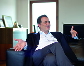 |
| Mehmet Güngen, owner of Güngen Maritime and Trading, explains his family-owned company's rise from shipping molasses to petroleum. |
Its function as a barrier between continents, a liquid line strung between Europe and Asia, has given the Bosporus such prominence in both history and legend: The ancient Greeks sailed up the strait to their Black Sea colonies; the Persian king Darius built a floating bridge across it in the fifth century bce; in 1451 ce, Mehmet the Conqueror built a fort on its European bank to strangle Constantinople; during the Cold War, Joseph Stalin said that Turkish control over the Bosporus held the ussr “by the throat”; today it is an essential part of the global shipping trade in petroleum.
From the Argonautica of Apollonius of Rhodes, an epic poem now almost 25 centuries old about Jason’s quest for the Golden Fleece, to the 1936 Montreux Convention and its many amendments, which guarantees free commercial passage to ships of any nation, almost as much ink as water has flowed through the Bosporus.
So it was a rare opportunity for a visitor to be invited to the bridge deck of the M/T (for Motor Tanker) Ottoman Nobility as it transited the strait from south to north, running empty to load oil at Novorossiysk, Russia, to deliver at Le Havre, France. The Nobility—of Suezmax size, the largest allowed in the Suez Canal—belongs to the fleet of a family-owned Turkish company, which got its start shipping sugar-beet molasses. Said Mehmet Güngen, one of the brothers, “We asked ourselves, if we could handle 30,000 tons of molasses in a single ship, why couldn’t we handle five times that tonnage of petroleum? After all, liquid cargo is liquid cargo.”
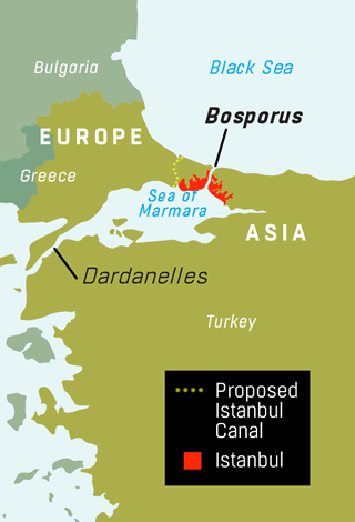 |
So much is known about the hazards of navigating the Bosporus, with its heavy traffic and its seven major turns—some through narrows barely twice as wide as the transiting ships are long—that the Turkish government’s recently announced plan to dig a parallel canal on the European side, to be completed on the nation’s 100th anniversary in 2023, does not seem farfetched, despite the prime minister himself calling it a “crazy idea”—not least because, as initially planned, it was too narrow and too shallow to allow for the water that transiting ships would displace and push out of the canal. The designated route, over hilly and unspoiled terrain, would require much excavation, unlike the Suez and Panama Canals, which took advantage of existing lakes at their midpoints.
Yet most people seem to agree that something must be done to protect both the Bosporus’s historic shoreline and its crowded shipping lane, which currently handles some 140 cargo vessels a day. Tanker traffic in particular is growing heavier as more oil is shipped from Black Sea ports. In 1979, the collision of a Greek freighter with the Romanian tanker Independenta at the strait’s southern mouth caused an explosion that shattered windows on land and left 94,000 tons of crude oil burning for weeks along the shore. Current computer simulations of the mid-strait explosion of a 1.1-million-barrel Suezmax cargo—half again as much as the Independenta’s—show utter devastation for a kilometer and a half (1 mi) on both shores.
The Nobility queues at anchor in the Marmara off Zeytin Burnu, Olive Point. After a day’s wait, it is released for transit on this Sunday afternoon under the command of Captain Levent Toker. Along as an observer is fleet superintendent Captain Tuğrul Vural. A pilot launch delivers the visitors to midships. Alongside the hull’s extra freeboard—the ship is empty and riding high—hangs a steeply pitched, 16-meter-long (50') gangway. The climb onto the main deck, and then up another four flights to the wheelhouse, makes one worry about scraping the underside of the two bridges we will pass under. In fact, there’s plenty of room: The bridges soar 64 meters (210') above sea level, and our ship rises only 42 meters (135') from the waterline.
In 1800, Jean-Baptiste Lechevalier correctly counted the seven articulated bends of the Bosporus, noting that each had a different current, a fact he observed by the changing colors of their surface waters whenever sudden rains diluted their salinity.
Captain Toker grew up swimming and fishing for sea bass in the Bosporus just off Rumeli Hisarı, the early Ottoman fort midway up the strait, built as part of the 1453 conquest of Constantinople. Captain Vural, with 27 years on the bridges of various ships, has passed through all of the world’s important straits, canals and even rivers, and he sees the Bosporus as his own front yard. A quick meal of rice and beans, always served Sundays at noon, marks the completion of another week of Captain Toker’s schedule—three months at sea for every month at home.
The second-century Greek geographer Dionysius of Byzantium wrote the earliest and most detailed topography of the Bosporus, which has given us a most apt aphorism related by Istanbul historian John Freely: he called it “a strait that surpasses all straits, because with one key it opens and closes two worlds, two seas.” Freely himself calls it “time’s river in the country of dreams,” and quotes Procopius, chronicler of the reign of the sixth-century Byzantine Emperor Justinian i, calling it “a garland of waters.”
Measuring fully 269 meters (861') stem to stern, the M/T Ottoman Nobility swings in the wind, anchored by 200 meters (640') of anchor chain, even though the water here is only 25 meters (175') deep. The anchor’s 15-ton weight, plus the chain’s additional 85 tons, is winched easily onto the 25,000-ton ship, straight into the boatswain’s store, where it jumbles into place next to neatly coiled ropes of more human dimensions. The two commands from the bridge that a deck mate listens for most closely—funda! (“drop anchor!”) and vira!(“hoist anchor!”)—indicate either homecoming or departure and, like many Turkish seafaring commands, come from Italian, thanks to centuries of Venetian and Genoese sea traders. On this ship, both commands are followed by bismillah (“in the name of God”).
The Bosporus is famous for its winds from all directions. Freely once spoke with an old captain in üsküdar who catalogued them from memory: yildiz, or the northerly Star Wind; the month of February’s keşişleme, bringing moisture from Mt. Uludağ to the southeast; karayel, or early winter’s Black Wind blowing from the northeast; the poyraz, named for Boreas, the Greek god of the north wind; lodos, named for Notos, the god of the south wind; and melteme, a northwest wind. The captain also remembered the names of storm systems that foretold the changing of the seasons: hüzün fırtınası, or spring’s Agreeable Storm; karakuş fırtınası, summer’s Storm of the Blackbirds; and balık fırtınası, autumn’s Fish Storm, harbinger of the running of the tuna, a Byzantine symbol that can be seen on some of the empire’s coins
Facing today a variable southerly wind and a constant northerly surface current attributed to the Black Sea’s cooler and less saline waters, the Nobility begins to move slowly toward the Bosporus’s lower mouth at less than half its top 15-knot speed. Toward Kadiköy, ancient Chalcedon, on the Asian side, it picks up the pilot who will help Captain Toker guide the ship on its 90-minute transit of the strait. Although Toker could handily navigate the strait alone, insurance rules require a specialist pilot on the bridge, and the Turkish government requires an escort tug off the tanker’s port bow, in case an engine or rudder failure requires emergency maneuvering.
The Bosporus is an unusually complex waterway because of its unique northward subsurface current, known to drag fishing boats north against the southward surface current if they cast their nets too deep. But strong north-bound winds can also cause the surface current to reverse course entirely and, at each bend, cause eddies and cross-currents at the strait’s alternating pinch points and wide bays. Apollonius called it “the eddying Bosporus,” and Ogier Ghiselin de Busbecq, the 16th-century Flemish author of the Turkish Letters, wrote that “buffeted against headlands ... it reaches Constantinople with many eddyings and bendings in one day’s journey,” accurately describing it as “bursting its way into the Marmara.”
The most precise early description of these currents was set down by the Frenchman Jean-Baptiste Lechevalier, whose Voyage de la Propontide et du Pont-Euxin was published in 1800. He wrote that “there exists no other straits in the world to which it can be compared—it surpasses all other in the beauty of its shorelines, the security of its anchorages, and the infinite variety of picturesque objects it offers the eyes of the navigator.” He correctly counted its seven articulated bends, each with a different current, which he observed by the changing colors of their surface waters whenever sudden rains diluted their salinity.
Partly because of these currents, once under way, the ship cannot easily stop. A small launch comes along midships and matches speeds, and the pilot grabs the lowest rung of the dangling gangway. He climbs the 16 meters of freeboard to reach the main deck.
The crew greets the pilot, Ahmet Turna, at the bridge with handshakes, and Turna sets about his business, eyeing the cross-strait commuter-ferry traffic, which is especially heavy between Kadiköy and üsküdar on the Asian side and Eminönü and Karaköy on the European. Turna and the others make a small and serious group. Besides the pilot and captain, a helmsman stands at the wheel, and each minute a navigator records heading changes in the ship’s maneuvers book, double-checking the electronic chart glowing onscreen against his well-used paper chart, plotting the course with parallel rulers and dividers, much as in days of old.
In a similarly redundant, fail-safe spirit, a waist-high magnetic compass on each wing deck outside the bridge stands ready in the event of a loss of the electronic compass. “Electronics, not the 17,000 horsepower of mechanical power—plus steam, electrical and hydraulics, which we also produce on board—is what makes a modern ship move,” says Toker, with only a bit of exaggeration.
The electronic chart glows with abundant information about depths and currents and plotted and actual course headings, as well as the positions of other large ships with gps transponders. The chart’s readout indicates that astern of us is the Captain Nihat—the name of the ship, not the name of its commander—but much of the pleasure-boat traffic goes unnamed and often unnoticed, as if they were so many ducks and geese. Disconcertingly, the bridge has a blind spot on the water over the bow that, when the empty ship is riding so high, stretches out in front about half a kilometer (0.3 mi), which puts the cause, if not the consequences, of near-collisions squarely on the shoulders of reckless yachtsmen and fishermen.
Disconcertingly, the bridge has a blind spot on the water over the bow that, when the empty ship is riding so high, stretches out in front about half a kilometer.
Procopius’s account of a 30-cubit-long sperm whale named Porphyrio, who menaced boats on the Bosporus for 50 years, may have been mostly fiction, and the hundreds of commuter ferries that travel up, down and across the strait may have attentive professional pilots of their own, but fishermen like Ufuk Doğan add a palpable risk to traffic control on these waters.
Ufuk often sets out before dawn on his small boat, heading from the Karaköy quayside under the Galata Bridge out to mid-channel, where he hopes to hook lüfer, or bluefish. While baiting his lines with needle-like zargana, he focuses on the tiny fry in his hands, not the huge hulls looming overhead. “We small fisherman don’t like tankers,” he says, “because their engine noise and dirty bilges ruin everything. My father, Alaatin, was known all over the Bosporus as a great fisherman, and he gave me this boat, hoping I would make my living as he did. It is no longer possible.”
The first of the seven turns the Nobility will have to make is 55 degrees to starboard—that’s to the right—and it takes place at the Kız Kulesi, or Maiden’s Tower, an islet off the Asian side just north of Kadiköy. It’s often called Leander’s Tower, though the strait that the Greek mythological character Leander swam across to visit his lover Hero was the Dardanelles, not the Bosporus. The Bosporus, meaning “cow ford” in ancient Greek, gets its name from another myth, that of the god Zeus and the nymph Io: Zeus seduced Io and then turned her into a cow to shield her from the wrath of his wife, Hera, but she was not fooled. In vengeance, Hera sent a biting fly to madden the animal, which finally escaped by swimming across to Asia.
Pilot Turna pays little attention to the electronic indicators overhead for radar, compass heading, depth, rudder angle and rate of turn. Instead, his eyes are always forward, looking at the ubiquitous Turkish flags flapping on hilltops and at the water’s edge on either shore, at the movement and height of the waves, and at how the smaller boats are faring that are more subject to currents and winds than the Nobility. “You must feel your way on each passage, not simply plot it before you set out. Each day is different. Which ferry will give you problems? Which changing wind will push your ship? All are questions without answers until you are on the bridge.”
The second turn, at Çengelköy, takes us to port (left) 30 degrees. Three long blasts help to clear the way through the unpredictable courses of motor yachts and sailboats, which on weekends are often captained by speed-loving amateurs. The pilot speaks methodically to the helmsman, who repeats his orders in a calm counterpoint of call and response to indicate turn speeds and rudder positions—“14 degrees per minute” or “rudder at zero degrees”—and compass headings. The pilot carries a fact sheet for each passage, with notations of current and wind speeds, but he relies foremost on instinct and experience, secondly on briefings from pilots who have just transited in the opposite direction, and only then on the written word.
Passing Bebek on the European side, just north of Akıntı Burnu, or Current Point, the Bosporus is at its greatest depth (100 meters or 162 feet), and here it runs the fastest. Captain Vural recalls his teenage years as a cadet in the nearby Maritime Academy, when for dawn training he pulled at the oars of his six-man boat with all his might against the eight-knot current, making minute progress into Bebek’s sheltered bay where the cadets took their breakfast. “If we were to miss a stroke or break an oar, we could quickly find ourselves down at the Galata Bridge, hungry all day.”
The third turn, between Kandili on the Asian side and Aşiyan opposite, under the Sultan Fatih Bridge, is where the Bosporus is at its narrowest—only 698 meters (2230') wide, and this requires a tricky double maneuver: first a 45-degree move to starboard, then almost the same turn to port. If the turning speed is above 25 degrees per minute, stability can be lost, so each turn must be anticipated in smooth, deliberate moves.
In the Argonautica, Apollonius pays tribute to those helmsmen brave enough to pilot ships through the Bosporus, recounting how a “monstrous wave reared up over the ship like a soaring mountain” and how the “excellent steersman Tiphys” stayed at the tiller. When the Argo did finally near the strait’s northern mouth at the Clashing Rocks, that pair of moving isles that smashed ships between them like cymbals, Jason released a dove, and when the dove passed safely between the rocks, the ship followed immediately. But a second wave approached suddenly, so “Tiphys eased off on the ship, which was struggling under the oars,” and “unharmed though terrified,” the Argonauts made it through.
“You must feel your way on each passage, not simply plot it before you set out," says Turna. "Each day is different. Which ferry will give you problems? Which changing wind will push your ship? All are questions without answers until you are on the bridge.”
The Nobility’s fourth turn, back to starboard at Kanlıca Point, just across from Istinye’s sharply indented harbor, precedes the tightest turn of the entire transit, an 80-degree maneuver to port at Yeniköy, followed closely by a return to starboard at the Asian side’s Umur shoals, across from Tarabya inlet. (Its name comes from the Greek therapeia, meaning “healing,” and refers to the neighborhood’s supposedly salubrious air.) Now appears the portside cape that the Byzantines called Kledai tou Pontu, the Keys to the Pontus. From here, an ever-widening view opens all the way to the Black Sea.
Pilot Turna, his job finished, disembarks onto a launch that pulls alongside the Nobility at a steady eight knots as he descends a rope ladder. As soon as the pilot boat veers off, the fast southerly current snaps it astern, making it drift quickly behind the tanker as it passes the Genoese castle above the fishing village and former Byzantine customs port of Anadolu Kavaği.
Further past Garipçe (“strange”) Point in Europe, across from Poyraz Burnu (“north wind point”), the ship passes the towers of a third Bosporus bridge under construction and finally clears what is left of the Clashing Rocks—the western one of the pair known in Turkish as öreke Taşı, or the Midwife’s Stool, now safely connected to the mainland by a causeway. From here, it will be a day and a half’s sailing to Novorossiysk.
Meanwhile, back at Sarai Burnu, or Palace Point, just below Topkapı, the former Ottoman palace, 55-year-old Yetkin Bodur is fishing. He’s after istavrit, or horse mackerel, but is having no luck today, so he is happy to put on fins and a diving mask to go pull lost hooks and rubber lures out of the shallows. A nearby diver, using an air hose pumped by an old compressor, fills baskets with mussels, which he will sell to itinerant vendors all over the city. “I have been coming here for 20 years,” Yetkin says, “always looking at the ships passing this way and that. Small or large, sail or diesel, sunny or stormy. The Bosporus never remains the same.”
 |
Louis Werner ([email protected]) is a writer and filmmaker living in New York. |
 |
Istanbul-based photojournalist Matthieu Paley (www.paleyphoto.com) specializes in documenting the cultures and lands of the Pamir, Karakoram and Hindu Kush mountain ranges. |


